 "davesaddiction @ opposite-lock.com" (davesaddiction)
06/23/2016 at 03:52 • Filed to: makin' hole
 0
0
 8
8
 "davesaddiction @ opposite-lock.com" (davesaddiction)
06/23/2016 at 03:52 • Filed to: makin' hole |  0 0
|  8 8 |
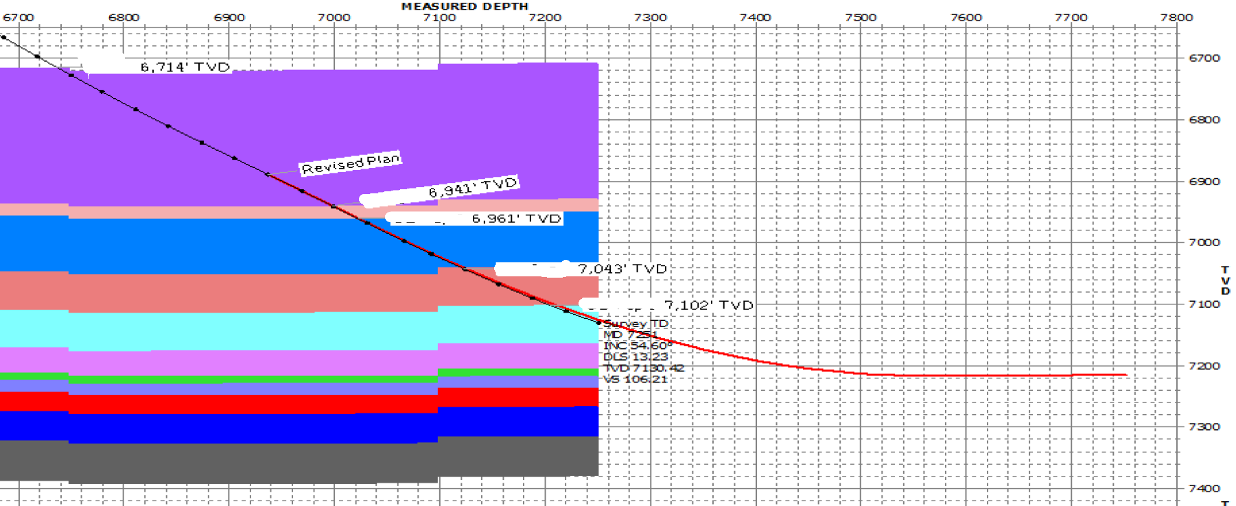
Waiting on the latest report from the field to confirm that our company’s first well is on track to land in the target formation according to plan. Exciting and a little nerve-wracking. Never ceases to amaze me how much control these guys can have over a drill bit on a length of pipe 1.5 miles below the surface of the Earth... Sleep will have to come in 2 hour increments until the bit stops turning. On track so far!

 Sam
> davesaddiction @ opposite-lock.com
06/23/2016 at 03:56 |
|
I’m assuming you have competent city workers to mark utilities? About 15 years back, my dad was running about 15 miles of fiber with a horizontal drilling machine. They hit an underground power line that was incorrectly marked and it blew the whole machine sky high.
 davesaddiction @ opposite-lock.com
> Sam
06/23/2016 at 04:09 |
|
Damn, that’s terrible... There’s no “city” out where this well is, but yeah, they know very well where everything is underground, and avoid things they don’t know exactly where with a wide berth.
 luvMeSome142 & some Lincoln!
> davesaddiction @ opposite-lock.com
06/23/2016 at 08:50 |
|
Can you explain that chart a little?
 Mmmmm
> davesaddiction @ opposite-lock.com
06/23/2016 at 09:36 |
|
What field?
 davesaddiction @ opposite-lock.com
> Mmmmm
06/23/2016 at 10:01 |
|
STACK - what else? haha
I recognize your videos from the Hallett Racing Group on Facebook!
 davesaddiction @ opposite-lock.com
> luvMeSome142 & some Lincoln!
06/23/2016 at 10:24 |
|
X axis is measured depth (MD) along the wellbore, like the length of a string that’s laid out in a curve. Y axis is true vertical depth (TVD), the actual depth from the floor of the drilling rig (sub-sea TVD, or SSTVD, takes into account depth below sea level and is expressed as a negative value). The red line is the plan line, and the dark blue dotted line is the actual directional survey. The color-filled areas represent layers of rock that we’re passing though and targeting. We use a tool that emits gamma rays to gather data (called a well log) to compare the character of the rock we’re drilling through to a nearby well’s GR log to confirm that we’re in the right location/reservoir. The “flat” part of the plan is what we’ll be completing the well in and producing from - this horizontal section will be just under a mile long (to fit within one PLSS section). Total MD from the plan is 12,000', or about 2.3 miles.
 luvMeSome142 & some Lincoln!
> davesaddiction @ opposite-lock.com
06/23/2016 at 10:30 |
|
Cool. Thanks for the explanation.
 davesaddiction @ opposite-lock.com
> luvMeSome142 & some Lincoln!
06/23/2016 at 11:06 |
|
Sure thing.